Scurvy de Bemaraha
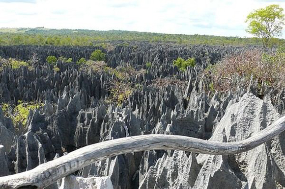
The natural wonder of the world - scurvy de Bemaraha (Tsingy de Bemaraha Reserve) - this limestone plateau, dotted with spikes of yellow limestone that form the real “stone forest”. The reserve is located about 80 kilometers off the west coast of Madagascar, stretching from the Bemaraha plateau to the river Manambulu. National Park, Madagascar, together with a unique “forest” occupies an area of 152 hectares.

The road to the Park scurvy de Bemaraha is very complicated and difficult, the roads are very bad, (average speed 15 km), only the road there and back takes 2 days, still need a day to explore the park.
The National Park has several names in Russian: the most popular scurvy de Bemaraha, as well as Tsinzhi du Bemaraha, Tsinzhi de Bemaraha.
Scurvy de Bemaraha - strange mineral forest reserve located about 80 kilometers off the west coast of Madagascar, a large part of the reserve is a ridge of teeth made of limestone, the Malagasy language they called “scurvy”. Scurvy de Bemaraha almost impenetrable maze of scurvy is the Malagasy term “walking on tiptoe.”
Scurvy de Bemaraha - is unique to Madagascar formation of minerals, called karst, has arisen as a result of erosion under the influence of acid rain and water, which gradually, over many centuries dissolve Cretaceous strata. Over time this led to the formation of stunningly beautiful karst landscapes and the 30-meter needle limestone that rise into the sky in an area of 152 sq.km. Some reach a height of fifty meters and carved canyons and narrow gorges.
Scurvy de Bemaraha declared a national park in 1927, this unusual stone “forest” was included in the UNESCO World Heritage Site in 1990. Part of the Park was opened to visitors in 1998.
Vertices are located so close together that the area is virtually impassable for humans, but not for the Lemur, which are there in abundance. These cute, nimble creatures look very strange on the background of the surrounding rocky and harsh terrain.
Local people say that throughout this region can hardly find a piece of flat land, big enough to put on his leg - a factor that helps to save at least part of Madagascar’s plants and animals from destruction.
National Park scurvy de Bemaraha consists of two parts - small and large scurvy scurvy. Small located at the entrance to the park. To big to ride another 17 kilometers from the park entrance. Go 17 kilometers takes about 2 hours.
The eastern boundary of protected areas is the cliff Bemaraha, which rises 400 meters above the valley of the river Monambolo. The northern part of the land that is closest to human settlements, and more accessible to the public, is a combination of rolling hills and yellow limestone spikes and barbs.
Scurvy de Bemaraha, Madagascar Walkways and bridges allow visitors to climb up from small areas of scurvy (known as the Petits Tsingy), using climbing equipment.
Scurvy de Bemaraha - a unique habitat for a huge number of wild animals and plants, some of which are endangered and protected. Numerous springs originate at the foot of the stone pillars, are an important source of drinking water for surrounding areas, especially western ones.
The national park scurvy de Bemaraha grow virgin tropical deciduous forests and thickets of xerophytic plants - lily, legumes, and Euphorbiaceae.
The fauna of the park - many rare species of birds, reptiles, and various kinds of lemurs (Wari, Maca, cat’s lemur) and their larger relatives Indra (short-tailed and Syphax).
Lemurs Sifakas, risk every day, using their long legs, they go from one rock to another, moving on karst forest reserve. Very little habitat remains for the lemurs, lemurs sifakas but still survive in the difficult balance between man and nature, due to difficult access to the reserve scurvy de Bemaraha. Eagles (Fisher eagles) are on the verge of extinction. They can be found on the banks of the river Manambolo, and in the National Park scurvy de Bemaraha.


